
The Mount Zion Project
Tomb of King David Archaeology Program
Jerusalem, Israel
History of Mount Zion
Mount Zion (Hebrew: הַר צִיּוֹן, Har Tsiyyon; Arabic: جبل صهيون, Jabal Sahyoun) is a hill in Jerusalem just outside the walls of the Old City. The term Mount Zion has been used in the Hebrew Bible first for the City of David (2 Samuel 5:7, 1 Chronicles 11:5; 1 Kings 8:1, 2 Chronicles 5:2) and later for the Temple Mount, but its meaning has shifted and it is now used as the name of ancient Jerusalem's Western Hill. In a wider sense, the term is also used for the entire Land of Israel.
The three different locations:
The name Mount Zion referred successively to three locations, as Jerusalemites preserved the time-honoured name, but shifted the location they venerated as the focal point of biblical Jerusalem to the site considered most appropriate in their own time.
Lower Eastern Hill (City of David)
At first, Mount Zion was the name given to the Jebusite fortified city on the lower part of ancient Jerusalem's Eastern Hill, also known as the City of David.
According to the Book of Samuel, Mount Zion was the site of the Jebusite fortress called the "stronghold of Zion" that was conquered by King David, then renamed and partially rebuilt by him as the "City of David", where he erected his palace.
Upper Eastern Hill (Temple Mount)
Once the First Temple was erected at the top of the Eastern Hill, the name "Mount Zion" migrated there too.
After the conquest of the Jebusite city, its built-up area expanded northward towards the uppermost part of the same, Eastern Hill. This highest part became the site of Solomon's Temple.
The identification of the pre-Israelite (Jebusite) and Israelite towns on the Eastern Hill is based on the existence of only one perennial water source in the area, the Gihon Spring, and on archaeological excavations revealing sections of the Bronze Age and Iron Age city walls and water systems.
The "Mount Zion" mentioned in the later parts of the Book of Isaiah (Isaiah 60:14), in the Book of Psalms, and the First Book of Maccabees (c. 2nd century BCE) seems to refer to the top of the hill, generally known as the Temple Mount.
Western Hill (today's Mount Zion)
The last shift of the name Mount Zion was to the Western Hill, which is more dominant than the Eastern Hill and seemed to first-century CE Jerusalemites the worthier location for the by-then lost palace of King David. The Western Hill is what today is called Mount Zion.
In the second half of the First Temple period, the city expanded westward and its defensive walls were extended to include the entire Western Hill behind them. Nebuchadnezzar II destroyed the city almost completely around 586 BCE, severing the continuity of historical memory. A long period of rebuilding followed, ending with Jerusalem's second total destruction at the hands of the Romans in 70 CE. Josephus, the first-century CE historian who knew the city as it was before this second catastrophic event, identified Mount Zion as being the Western Hill, separated from the lower, Eastern Hill, by what he calls the "Tyropoeon Valley". It must however be said that Josephus never used the name "Mount Zion" in any of his writings, but described the "Citadel" of King David as being situated on the higher and longer hill, thus pointing at the Western Hill as what the Bible calls Mount Zion.
History since the Late Roman period
At the end of the Roman period, a synagogue was built at the entrance of the structure known as David's Tomb, probably based on the belief that David brought the Ark of the Covenant here from Beit Shemesh and Kiryat Ye'arim before the construction of the Temple.
During the 1948 war, Mount Zion was conquered by the Harel Brigade on May 18, 1948 and became the only part of the Old City to stay in Israeli hands until the armistice. At first it was linked to the Jewish neighborhood of Yemin Moshe across the Valley of Hinnom via a narrow tunnel, but eventually an alternative was needed to evacuate the wounded and transport supplies to soldiers on Mt. Zion. A cable car capable of carrying a load of 250 kilograms was designed for this purpose. The cable car was only used at night and lowered into the valley during the day to escape detection; it is still in place at what is now the Mount Zion Hotel. The ride from the Israeli position at the St. John Eye Hospital to Mount Zion took two minutes.
Between 1948 and 1967, when Jerusalem’s Old City was under Jordanian rule, the closest that Israelis could come to the Temple Mount was Mount Zion, a hill just outside the walls on the southern end of the Old City. Until East Jerusalem was captured by Israel in the Six-Day War, Israelis would climb to the rooftop of David's Tomb to pray. The hill has been called Mount Zion since sometime in the Middle Ages, even though Jewish scripture refers to the Temple Mount by the same name.
Interestingly enough, legend has it that Sultan Suleiman the Magnificent initially meant for Mount Zion to be inside the walls of the Old City. However, the Turkish engineers who were planning the restoration of the walls accidentally left Mount Zion and King David’s Tomb outside the walls, prompting the livid sultan to execute them. Among the important sites and landmarks on Mount Zion are the Room of the Last Supper, King David’s Tomb, the Chamber of the Holocaust, and the Protestant Cemetery. In addition Oskar Schindler is buried here as a righteous gentile, and the Dormition Abbey is located here.
Ref: https://en.wikipedia.org/wiki/Mount_Zion

Mount Zion - Photo courtesy of Jerusalem Intercultural Center
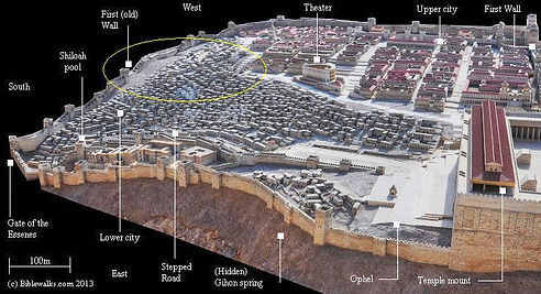
Jerusalem Museum model of Herod's Jerusalem - south side,
with Mount Zion area circled yellow. Photo courtesy of Biblewalks.com


King David's Tomb, Cenacle Room & King David Statue

Oskar Schindler’s gravesite
photo courtesy http://www.teresathetraveler.com

Dormition Abbey